Getting there
- Flights to Arusha (JRO) 35 km from the start
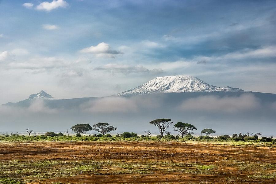
Treks / Tanzania
Tanzania · Nearest city: Moshi (also Arusha)
A non-technical climb to the roof of Africa. Summit night starts around midnight and involves roughly 1,200 m of ascent followed by a long descent the same day.
Watch out: Altitude, not fitness, is why roughly four in ten climbers don't summit. Choose a 7-day itinerary if you can.
It's the highest mountain you can walk up without climbing skills, and one of the Seven Summits.
The seven-day Machame route, the most popular way up Kilimanjaro. Every night is at a designated camp and a licensed guide is compulsory.
Dense rainforest with monkeys, often misty and muddy.
Sleep: Machame Camp
Out of the forest onto open moorland, with Kibo's summit in view.
Sleep: Shira Camp
Climb high to Lava Tower, sleep low at Barranco among giant groundsels.
Sleep: Barranco Camp (3,960 m)
A fun, hands-on scramble up the Barranco Wall, then a short day for acclimatisation.
Sleep: Karanga Camp (3,995 m)
A short climb to base camp, early dinner and bed before the midnight start.
Sleep: Barafu Camp
Night climb to Stella Point and Uhuru Peak at sunrise, then a long descent.
Sleep: Mweka Camp (3,100 m)
Back down through the rainforest to collect your certificate.
Sleep: Hotel in Moshi or Arusha
Summit day. You reach Stella Point on the crater rim around sunrise, with glaciers and the plains of Tanzania glowing below, then walk the rim to Uhuru Peak.
There's no rest day as such: days 3 and 4 are built for acclimatisation, climbing to Lava Tower at 4,630 m and sleeping lower at Barranco.
Some of these are affiliate links: if you book through them we may earn a small commission, at no extra cost to you. We only list services that fit this trek.
Roaming in Tanzania is expensive on most phone plans. A data eSIM bought before you fly gets you online as soon as you land.
Expect long stretches with no signal on the trail. Download offline maps and our GPX before you start.
This trek reaches 5,895 m. Above 4,500 m most standard policies stop, so check the altitude limit before you buy: SafetyWing needs its Adventure Sports add-on (up to 6,000 m), World Nomads covers trekking to 6,000 m with Level 3 activities, and Heymondo's add-on stops at 5,000 m. Above 4,600 m, Global Rescue's High-Altitude package adds field rescue.
Rescue is not the same as evacuation. Travel insurance usually pays to fly you to hospital, but not always for the search and rescue itself. Read the policy's "search and rescue" section.
True Traveller sells only to UK and EEA residents. Always check the altitude limit and your country of residence in the policy wording. Our trekking insurance guide explains what to look for.
All camping is at the national park's designated campsites, organised by your tour operator.
Rules change and differ between parks. Check with the local park or tourist office before you pitch a tent.
Map layers load on the live site. Use the overview below meanwhile.
Straight lines between stops One colour per day (dashed: straight line, not the exact path) Start / finish Stop on the way Nearest city
Switch between Topo, Satellite and Street layers with the layer button, and turn on the marked hiking trails overlay. We don't have the exact trail for this route yet, so stops are joined with straight lines. Always carry a proper hiking map on the trail.
Stops: Machame → Barafu Camp → Uhuru Peak
Best time: January to mid-March, June to October
The dry seasons (see best season above)
Clearest skies and most stable weather, but cold nights at altitude and busy trails.
Bring
Edges of the dry season
Fewer people and cheaper trips, with a higher chance of cloud, rain or snow.
Bring
Rainy months
Mud, cloud and closed views. Some routes close entirely, like the Inca Trail in February.
Bring
Above about 3,000 m the air holds less oxygen. Walk slowly, drink plenty, don't rush acclimatisation days, and go down if you get a bad headache, nausea or confusion.
Summit temperatures can drop well below freezing, especially before dawn. Pack a down jacket, warm gloves and a hat.
9 photos taken on and around the route by Wikimedia Commons photographers. Tap one to see it bigger.
Photo credits: Kilimanjaro from Amboseli by Sergey Pesterev, CC BY-SA 4.0, via Wikimedia Commons; Fresh Tracks above the Clouds on a Fresh Morning - Be careful you don't walk off the cliff by Shane (Lost Australian), CC BY 2.0, via Wikimedia Commons; Rainbow and Barranco wall, Barranco camp, Kilimanjaro region, Tanzania by KpokeJlJla, CC BY-SA 4.0, via Wikimedia Commons; Riesensenezien - panoramio by Stefan090281, CC BY 3.0, via Wikimedia Commons; Climbing toward the Lava Tower site, Kilimanjaro, - Aug. a by Masa Sakano from Leicester, UK, CC BY-SA 2.0, via Wikimedia Commons; Karanga Camp (4000m) Kilimanjaro by Phase9, CC BY-SA 3.0, via Wikimedia Commons; Kilimanjaro climb - panoramio by Jang Woo Lee, CC BY 3.0, via Wikimedia Commons; Corvus albicollis on Kilimanjaro by Masa Sakano, CC BY-SA 2.0, via Wikimedia Commons; Kilimanjaro,Tanjania - panoramio by Jang Woo Lee, CC BY 3.0, via Wikimedia Commons. Photos resized for the web. Figures are approximate and vary with the variant you choose.

.jpg)

.jpg)

_Kilimanjaro.jpg)


