Getting there
- Flights to Lukla (LUA) right by the start
- Flights to Kathmandu (KTM) 135 km from the start
Treks / Nepal
Nepal · Nearest city: Kathmandu (also Lukla)
A round trip from Lukla through Sherpa villages to the foot of Everest. Daily distances are moderate, but you sleep above 4,000 m for most of a week.
Watch out: Acclimatisation days are not optional. Flights to and from Lukla are often delayed by weather.
It takes you to the foot of the world's highest mountain through Sherpa villages and Buddhist monasteries.
The classic round trip from Lukla, sleeping in teahouses (simple lodges) every night. Two acclimatisation days are built in and shouldn't be skipped.
After the famous flight into Lukla, an easy walk along the Dudh Kosi river.
Sleep: Teahouse in Phakding
Suspension bridges and a steep climb, with your first glimpse of Everest on the way up.
Sleep: Teahouse in Namche
Acclimatisation day with a short climb to the Everest View Hotel.
Sleep: Teahouse in Namche
The monastery at Tengboche with Ama Dablam towering behind it.
Sleep: Teahouse in Tengboche
Above the trees now, into stone-walled fields under Ama Dablam.
Sleep: Teahouse in Dingboche
Acclimatisation day: a climb up the ridge above the village and back down.
Sleep: Teahouse in Dingboche
Past the climbers' memorials at Thukla Pass.
Sleep: Teahouse in Lobuche
Along the Khumbu glacier to Base Camp and the Khumbu Icefall, then back to Gorak Shep.
Sleep: Teahouse in Gorak Shep (5,164 m)
Pre-dawn climb up Kala Patthar for sunrise on Everest, then a long descent.
Sleep: Teahouse in Pheriche (4,240 m)
A long day down, with thicker air making it feel easy.
Sleep: Teahouse in Namche
Last day on the trail, and a party with your guides and porters.
Sleep: Teahouse in Lukla
Sunrise from Kala Patthar on day 9, at about 5,545 m, is the classic close-up view of Everest's summit. Base Camp itself sits below the mountain and doesn't show the top.
Namche Bazaar (day 3) and Dingboche (day 6). Use them for short climbs higher before sleeping low again.
Some of these are affiliate links: if you book through them we may earn a small commission, at no extra cost to you. We only list services that fit this trek.
Roaming in Nepal is expensive on most phone plans. A data eSIM bought before you fly gets you online as soon as you land.
Expect long stretches with no signal on the trail. Download offline maps and our GPX before you start.
This trek reaches 5,364 m. Above 4,500 m most standard policies stop, so check the altitude limit before you buy: SafetyWing needs its Adventure Sports add-on (up to 6,000 m), World Nomads covers trekking to 6,000 m with Level 3 activities, and Heymondo's add-on stops at 5,000 m. Above 4,600 m, Global Rescue's High-Altitude package adds field rescue.
Rescue is not the same as evacuation. Travel insurance usually pays to fly you to hospital, but not always for the search and rescue itself. Read the policy's "search and rescue" section.
True Traveller sells only to UK and EEA residents. Always check the altitude limit and your country of residence in the policy wording. Our trekking insurance guide explains what to look for.
Almost everyone stays in teahouses. Camping trips exist but need a licensed operator.
Rules change and differ between parks. Check with the local park or tourist office before you pitch a tent.
Map layers load on the live site. Use the overview below meanwhile.
Trail from OpenStreetMap (53.7 km) One colour per day Start / finish Stop on the way Nearest city
Switch between Topo, Satellite and Street layers with the layer button, and turn on the marked hiking trails overlay. The trail line is the OpenStreetMap hiking route and may differ from the variant you choose. Always carry a proper hiking map on the trail.
Stops: Lukla → Namche Bazaar → Tengboche Monastery → Gorak Shep → Everest base camps
Best time: March to May, late September to November
The dry seasons (see best season above)
Clearest skies and most stable weather, but cold nights at altitude and busy trails.
Bring
Edges of the dry season
Fewer people and cheaper trips, with a higher chance of cloud, rain or snow.
Bring
Rainy months
Mud, cloud and closed views. Some routes close entirely, like the Inca Trail in February.
Bring
Above about 3,000 m the air holds less oxygen. Walk slowly, drink plenty, don't rush acclimatisation days, and go down if you get a bad headache, nausea or confusion.
Summit temperatures can drop well below freezing, especially before dawn. Pack a down jacket, warm gloves and a hat.
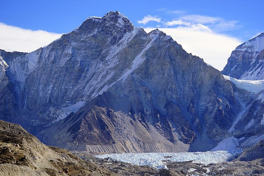
10 photos taken on and around the route by Wikimedia Commons photographers. Tap one to see it bigger.
Photo credits: Khumbutse by Peellden, CC BY-SA 3.0, via Wikimedia Commons; Namche Bazaar Nepal by stevehicks, CC BY 2.0, via Wikimedia Commons; Lukla and Lukla Airport, Nepal by Vyacheslav Argenberg, CC BY 4.0, via Wikimedia Commons; View near Namche Bazaar by Guillaume Baviere from Uppsala, Sweden, CC BY-SA 2.0, via Wikimedia Commons; View near Namche Bazaar by Guillaume Baviere from Uppsala, Sweden, CC BY-SA 2.0, via Wikimedia Commons; View near Gorak Shep by Guillaume Baviere from Uppsala, Sweden, CC BY-SA 2.0, via Wikimedia Commons; View near Phakding by Guillaume Baviere from Uppsala, Sweden, CC BY-SA 2.0, via Wikimedia Commons; View near Phakding by Guillaume Baviere from Uppsala, Sweden, CC BY-SA 2.0, via Wikimedia Commons; View near Tengboche by Guillaume Baviere from Uppsala, Sweden, CC BY-SA 2.0, via Wikimedia Commons; View near Tengboche by Guillaume Baviere from Uppsala, Sweden, CC BY-SA 2.0, via Wikimedia Commons. Photos resized for the web. Figures are approximate and vary with the variant you choose.


.jpg)
.jpg)
.jpg)
.jpg)
.jpg)
.jpg)
.jpg)