Getting there
- Flights to Glasgow (GLA) 10 km from the start
Treks / United Kingdom (Scotland)
United Kingdom (Scotland) · Nearest city: Glasgow (also Fort William)
Scotland's most popular long-distance path, from Milngavie to Fort William. Long days on mostly good paths, with rain and midges as the main opponents.
Watch out: Rain gear and blister care matter more than hill fitness here. Midges peak in summer.
It's the classic first long-distance walk: easy to reach from Glasgow, well waymarked, with pubs and B&Bs every night and the Highlands getting wilder every day.
The standard eight-day itinerary from Milngavie to Fort William. Distances are approximate and there are plenty of places to split or shorten stages.
Farmland and the Campsie Fells. The Glengoyne distillery is a short detour.
Sleep: B&Bs and inns in Drymen
Your first view of Loch Lomond and its islands from the top of Conic Hill.
Sleep: Rowardennan hostel or hotel, Sallochy campsite
A rough, rooty path right along the loch. Slower than the distance suggests.
Sleep: Drovers Inn, Beinglas Farm campsite
Waterfalls in Glen Falloch and the first real Highland scenery.
Sleep: Hostels, B&Bs and campsite in Tyndrum
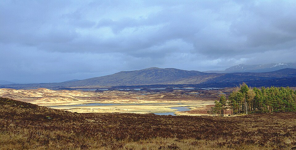
The crossing of Rannoch Moor ending under Buachaille Etive Mòr, the most photographed mountain in Scotland.
Sleep: Kingshouse Hotel, Bridge of Orchy
The highest point of the route, with views back over Glencoe's peaks.
Sleep: Hostels and hotels in Kinlochleven
An old military road through a remote glen, with Ben Nevis appearing near the end.
Sleep: Fort William
Loch Lomond from Conic Hill on day 2, and the pyramid of Buachaille Etive Mòr as you reach Kingshouse on day 5.
Tyndrum, after day 4, has shops, cafés and the famous Real Food Café. The short stage to Kinlochleven on day 6 also works as a lighter day.
Some of these are affiliate links: if you book through them we may earn a small commission, at no extra cost to you. We only list services that fit this trek.
EU 'roam like at home' doesn't apply in United Kingdom, and many plans charge extra there. A Europe data eSIM covers United Kingdom too.
Expect long stretches with no signal on the trail. Download offline maps and our GPX before you start.
Most travel insurance includes hiking at this height. Check that hiking is listed and that medical evacuation is covered.
Rescue is not the same as evacuation. Travel insurance usually pays to fly you to hospital, but not always for the search and rescue itself. Read the policy's "search and rescue" section.
True Traveller sells only to UK and EEA residents. Always check the altitude limit and your country of residence in the policy wording. Our trekking insurance guide explains what to look for.
Wild camping is allowed in most of Scotland under the Scottish Outdoor Access Code, but along the east shore of Loch Lomond you need a permit from March to September. Campsites are spread along the whole route.
Rules change and differ between parks. Check with the local park or tourist office before you pitch a tent.
Map layers load on the live site. Use the overview below meanwhile.
Trail from OpenStreetMap (153.4 km) One colour per day Start / finish Stop on the way Nearest city
Switch between Topo, Satellite and Street layers with the layer button, and turn on the marked hiking trails overlay. The trail line is the OpenStreetMap hiking route and may differ from the variant you choose. Always carry a proper hiking map on the trail.
Stops: Milngavie → Drymen → Rowardennan → Tyndrum → Kinlochleven → Fort William
Best time: April to October
April to May
Often the driest time of year, with long days and fresh green hills. Can still be cold and windy on the tops.
Bring
June to August
Longest days and warmest weather, but also rain showers, busier trails and, in Scotland, midges.
Bring
September to October
Fewer people and beautiful colours, but wetter, windier weather and shorter days.
Bring
Plan for rain on most days. A proper waterproof jacket, a pack liner and quick-dry clothes keep you comfortable.
Scottish midges swarm on calm, damp days from June to September. A head net and repellent are essential.
Expect 7–10 hour days. Start early, eat little and often, and know your turnaround time.
9 photos taken on and around the route by Wikimedia Commons photographers. Tap one to see it bigger.
Photo credits: WHW Rannoch-Moor by Mogens Engelund, CC BY-SA 3.0, via Wikimedia Commons; Buachaille Etive Mor by Doug Lee, CC BY-SA 2.0, via Wikimedia Commons; Milngavie-Center by MartinThoma, CC0, via Wikimedia Commons; Inverarnan, Wooded area by the River Falloch - geograph.org.uk by Michael Garlick, CC BY-SA 2.0, via Wikimedia Commons; Lochan Mhic Pheadair Ruaidh from the West Highland Way - geograph.org.uk by Iain Lees, CC BY-SA 2.0, via Wikimedia Commons; Towards the Mamore Forest from the top of the West Highland Way - geograph.org.uk by Richard Law, CC BY-SA 2.0, via Wikimedia Commons; Semegen Animals - Sarah Semegen by University of Michigan School for Environment and Sustainability from Ann Arbor, CC BY 2.0, via Wikimedia Commons; Bridge across the River Falloch - geograph.org.uk by Alan Walker, CC BY-SA 2.0, via Wikimedia Commons; Shoreline of Loch Lomond, towards Rowardennan Youth Hostel - geograph.org.uk by Peter S, CC BY-SA 2.0, via Wikimedia Commons. Photos resized for the web. Figures are approximate and vary with the variant you choose.


.jpg)

